The number of aerial platforms and projectiles is increasing phenomenally. Civil aviation is the fastest growing transportation sector. Military is using very high speed aircraft, long range missiles, including ballistic, many of which are flying at hypersonic speeds. Unmanned systems and drones are the new entrants in this huge expanse of aerospace. LEO space altitude band is chock-a-block with satellites and constellations. Air and space have unending volume. Movements of platforms are three dimensional. Global military spend was 2.44 trillion U.S. dollars in 2023. Of this, 40 percent was on aerospace. The action is thus going to continue to increase.
Indian Navy has set up an Information Fusion Centre–Indian Ocean Region (IFC-IOR) at Gurugram for maritime domain awareness. Most naval ships, including the fishing boats, are expected to report or transmit their position, therefore it is possible to create a live domain awareness picture, and share with Friendly Foreign Countries (FFC). It is a collaborative approach. Compared to aerial platforms, the ships are very slow moving vehicles. Having a similar arrangement for the air is thus a little more complex.
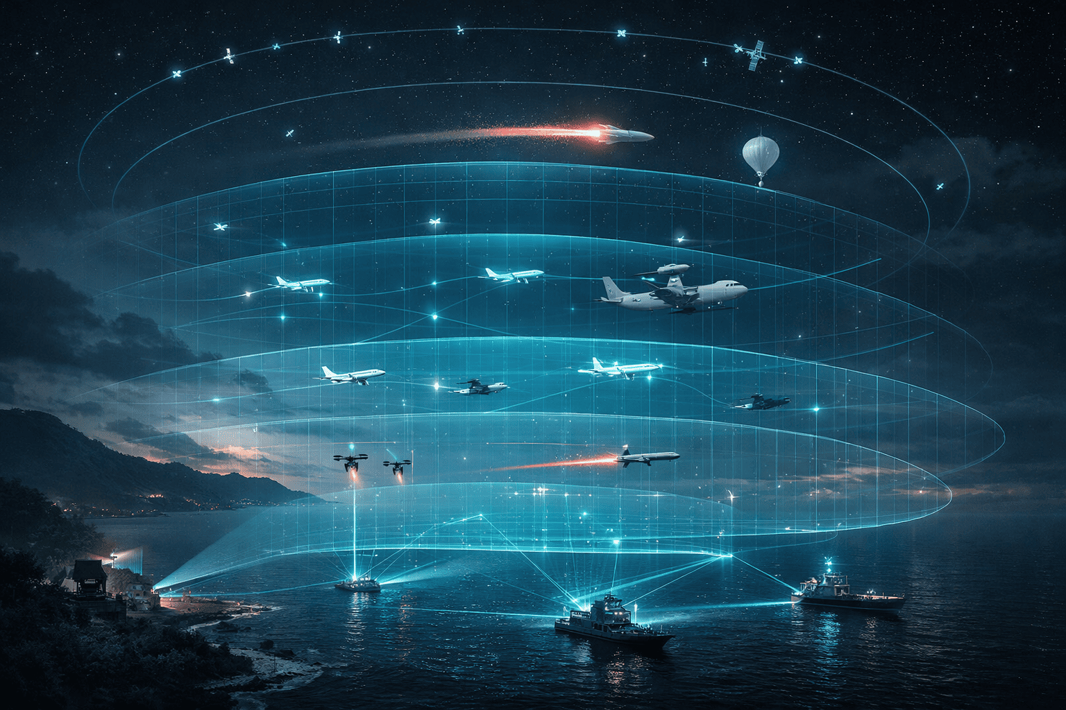
The world is already evolving Space Domain Awareness (SDA). The Near Space is the region between space and flight permitting atmosphere. More aerial platforms, including high-altitude balloons, pseudo satellites, and some missiles, have begun using this region. Most major countries have begun considering air and space as one continuum and combining the two domains under one operational grouping. The scope of aerospace awareness becomes huge. In fact practitioners are already talking of the idea of “domain awareness superiority.” During the Indian Air Force’s (IAF) multi-lateral exercise “Tarang Shakti” a symposium was held at Jodhpur to look at Air Domain Awareness (ADA). Let us see how ADA can be created.
What is Air Domain Awareness?
For long the aircrew were using the term Situation Awareness (SA) around themselves. Similarly the commanders would need SA, and sectorial level for planning and decision making. Advances in radar and other sensors, their networking, high speed information processing, Artificial Intelligence (AI) and Machine Learning (ML) have made it possible to create the big picture Domain Awareness. Advanced 5th generation C4ISR (Command, Control, Communications, Computers, Intelligence, Surveillance, and Reconnaissance) solutions designed for speed of action allow ADA over huge volume of airspace transcending land masses and oceans across continents. Such awareness will greatly support peace-time operations. Of course during conflict the information sharing restrictions could partly impact ADA. To build a larger ADA, FFC must partner, share information, create real-time ADA, and also individually benefit. It will require meshing and fusing of data of all military and civil radars including airborne and sea-borne sensors, among others.
Key Attributes of ADA
Air covers a huge volume of space. The ADA must globally cover from sea level to nearly 75,000 feet (23 kilometres) altitude, till which some aerial platforms may fly. Persistency would require 1–8 second update interval. Less than 2 second low latency will be desired. The ADA availability must be close to 99 percent. It should be resilient with overlapping coverage. All partners must share maximum information and data. The architecture would have to include encryption and cyber-spoofing detection capabilities. It should be easily accessible to partners. Lastly independent verification and validation of positional data should be possible and must be done. Ultimately each country should be able to mesh ADA with Joint All Domain Command and Control network architecture.
Maritime Domain Awareness
Maritime Domain Awareness (MDA) is defined by the International Maritime Organization (IMO) as the effective understanding of anything associated with the maritime domain that could impact the security, safety, economy, or environment. MDA is said to work as a key enabler for other maritime security issues, such as anti-piracy patrols, in the way that in order to do effective patrols you need to have the ability of conducting effective MDA.
In the last few years, India has completed numerous organizational and operational changes to create a national MDA grid. Toward this end, the Indian Navy (IN) has set up the National Command, Control, Communication, and Intelligence (NC3I) network that hosts the Information Management and Analysis Centre (IMAC). Managed jointly by the IN and the Indian Coast Guard, IMAC is responsible for connecting, collating, fusing, and disseminating actionable information and critical real-time intelligence over its entire coastline and the island territories. The system also receives vital operational data from the coastal radar stations, Automatic Identification Systems (AIS), long-range identification and tracking data from Maldives, Mauritius, Seychelles, Sri Lanka, Bangladesh, and Myanmar through white shipping arrangements.
In 2018, the scope of IMAC was further expanded with the launch of the National Information Fusion Centre–Indian Ocean Region (IFC-IOR), a maritime information hub for the region. Having established collaborative links with 97 other centres in 41 countries, the IFC-IOR coordinates with like-minded stakeholders in multilateral information-sharing networks and provides actionable information to maritime agencies. The Indo-Pacific Partnership for Maritime Domain Awareness (IPMDA) was unveiled in May 2022 during the Quadrilateral Security Dialogue (Quad) leaders’ summit in Tokyo. It extends information-sharing support between the IFC-IOR and other regional fusion centres.
Space Domain Awareness
Space Domain Awareness (SDA) is the study and monitoring of satellites orbiting the Earth. It involves the detection, tracking, cataloguing, and identification of artificial objects, including active/inactive satellites, spent rocket bodies, or fragmentation debris. It allows predicting when and where a decaying space object will re-enter the Earth’s atmosphere. It also helps differentiate between a returning space object, which to radar looks like a missile, from triggering a false alarm in missile-attack warning sensors. Charting the present position of space objects and plotting their anticipated orbital paths. Detecting new man-made objects in space. Knowing the ownership of each space object. Cautioning for possible collisions.
The tracking and composing the SDA 3D picture involves ground-based electro-optical deep-space surveillance telescopes; detectors such as the Space Fence; information from space-based sensors; bi-static radar-based space surveillance systems.
India is working on SDA in a number of ways, including through collaboration with FFCs including USA through INDUS-X initiative to develop SDA technologies for tracking satellites in Low Earth Orbit (LEO). There is a SDA Centre in Bengaluru that monitors space traffic to ensure satellite safety. Digantara is building a Space-MAP to help with space operations and situational awareness. Goal is to have debris-free space missions. It’s important for securing space assets and ensuring the safety of space operations.
IAF’s Integrated Air Command and Control System
IAF’s Integrated Air Command and Control System (IACCS) is an automated command and control system for total air domain awareness and for executing all kinds of defensive and offensive air operations. IACCS operations ride the secure Air Force Net (AFNET) backbone integrating all ground-based and airborne sensors, air defence (AD) weapon systems and command and control (C2) nodes. The feeds from other services’ networks and civil radars provide an integrated national Air Situation Picture.
Through the IACCS, IAF is connecting all of its space, air and ground assets, for total awareness of a region. The IACCS also facilitates real-time transport of images, data and voice, amongst satellites, aircraft and ground stations.
How to Go About Expanding ADA
While the global MDA and SDA are already established and growing, the same cannot be said about ADA. But each sovereign nation has its own military and civil sensors networked to create an air picture over its land and sea borders. It is selectively shared between various agencies to monitor aviation activity. The system of sharing is currently limited to friendly alliances as is the case within NATO.
The starting point is to have a very large number of sensors covering the entire air space. These will include space-based assets, ground-based radars, including Over-the-Horizon (OTH) radars. Airborne Early Warning (AEW) platforms, Uncrewed Aerial Vehicles (UAV) sensors will be integrated. Naval and coastal radars and ship-based sensors will give a feed. There should be radars at island territories or picketed ships covering parts of seas and oceans.
The three-dimensional air picture should be created fusing the information. The actionable information should then be shared with FFCs without creating overload. For this secure interconnectivity must be established which precludes eavesdropping.
The technologies for all these already exist. Most sensors are in place or will get added. Near Space should be included in ADA. Ultimately the SDA and MDA pictures must be selectively super imposed over ADA to make a complete big picture.
Way Ahead
There is a general consensus among operators that ADA is very important for national security, operational efficiency, aviation safety, rescue operations, and preventing hostile actions by rogue elements and non-state actors. The ADA will greatly support Humanitarian Assistance and Disaster Relief (HADR) operations at regional and global scale. The ADA must be fused with SDA and MDA at a later date. Advanced nations must take the lead in creating a structure and sharing technologies with others.
Conflict zone data filtration can be built in. Geopolitical sensitivities of nations for sharing certain data will have to be factored. Beginning must be made by taking baby-steps. India can take initiative in the Bay of Bengal area by collaborating with Thailand, Bangladesh, Sri Lanka, and Malaysia. A broader architecture can be evolved jointly with countries like USA, France, and Japan, among a few others. The Regional ADA Centre can be set-up in Delhi National Capital Region (NCR).
IAF’s considerable experience and success with its automated IACCS that gives out a Recognized Air Situation Picture (RASP) has to be used. IAF is the natural agency to drive such an initiative. It is time to get going.
Note: The article was originally written by the Author for Indian Aerospace Defence Bulletin on 4th, October 2024, it has since been updated.
Header Picture Credit: Representative Image Generated using AI
Twitter: @AirPowerAsia
